Effortlessly detect patterns, anomalies and relationships in your geoscience data.
Download nowEnquire now


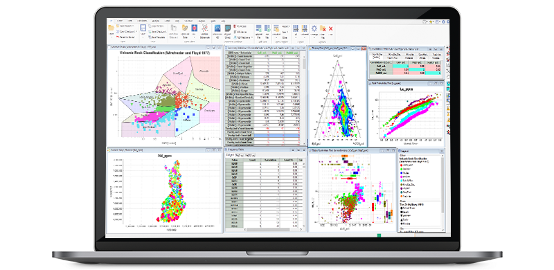
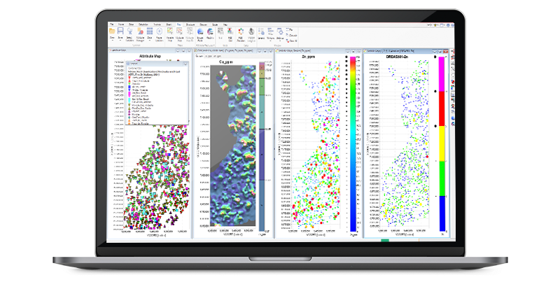
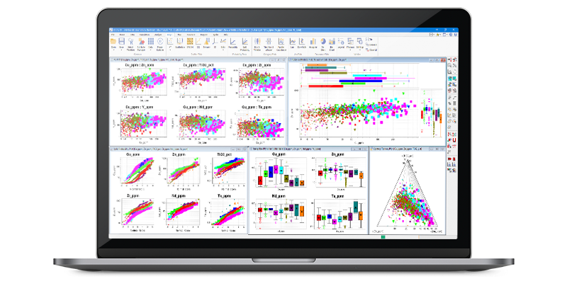
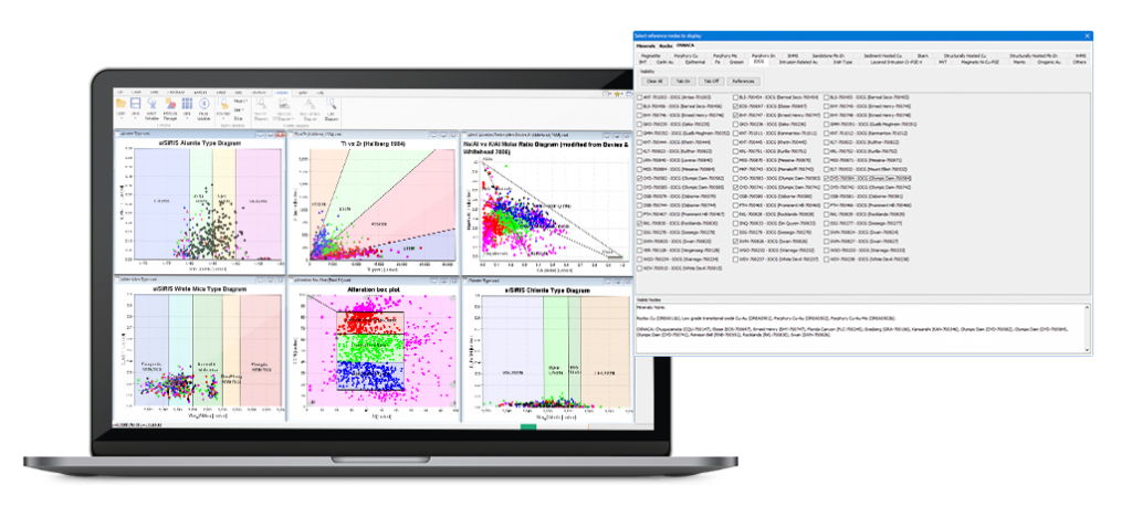
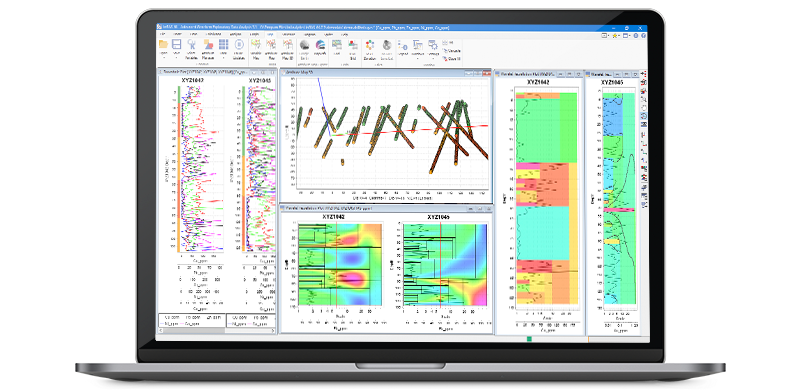
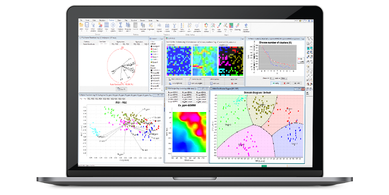
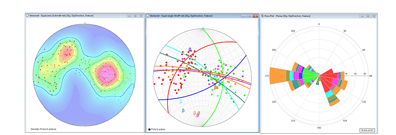
ioGAS™ is a leading exploratory data analysis software application developed specifically for the resources industry. Traditional methods to analyse results could take many hours and is always prone to human error, ioGAS™ in comparison can generate accurate results in a fraction of the time. Over the past decade a wide range of visual analytics and advanced quantitative tools have been developed to obtain a greater insight into the underlying structure of your data.
Technical Specifications
Download the latest version of ioGAS™ by clicking on the link below. The software is installed into a new folder and existing users* must have a valid licence file in order to run the latest version. A two week trial period is available for new users. Select more information to see what’s new in ioGAS™ 8.1 or refer to the Help file within ioGAS™.
Download NowMore Information*Existing users can also download the latest version of IMDEX ioGAS™ via Check for Updates on the Help Ribbon within ioGAS™.
Looking for IMDEX ioGAS™ plugins?

IMDEX and SEEQUENT have combined to produce the ioGAS™-Leapfrog live link for rapid 3D visualisation of geochemical data in real-time. Geoscientific data can be analysed in ioGAS and then visualised and modelled in the 3D environment using Leapfrog Geo. Geochemistry parameters can be added as new attributes and transformed into 3D interpolants for enhancing geological models.
The ioGAS™ Link is sold and licensed as a separate add-on to the Leapfrog Geo software. The link will only run with an active licence of Leapfrog Geo, enabled for the ioGAS™ Link. You will also need Leapfrog Geo v1.3 or later and ioGAS™ v5.0 or later. For further information including how to obtain a trial version of the Leapfrog Geo software or to purchase the ioGAS™ Link please contact your local Leapfrog sales team.
More InformationThis plugin is developed by IMDEX and includes a live link to view and refresh data in ioGAS and QGIS in real time. Alternatively, .gas files can be imported into QGIS as temporary scratch layers or GeoPackage files. The plugin is compatible with Windows or Mac OS operating systems and requires a long term release installation of QGIS 3.22 or later and ioGAS 7.3.
This add-in is developed by IMDEX to import ioGAS™ attribute map symbology and supporting data into ArcGIS Pro as a point layer. Data is imported as an attribute point feature class in the project default geodatabase. Requires installed versions of ArcGIS Pro 3.0 and ioGAS 8.0 or later .
Geoscience ANALYST is a free 3D visualisation and communication software for integrated, multi-disciplinary earth models and data developed by Mira Geoscience. The ioGAS™ for Geoscience ANALYST link is available in Geoscience ANALYST Pro, an add-on module which offers object and data editing and creation functionality, data analysis, interpretation tools and utilities.
The link is purchased separately through Mira Geoscience and activated via the Geoscience ANALYST Pro licence. Contact [email protected] for more information.
More InformationGOCAD® Mining Suite is a customised extension of the SKUA-GOCAD™ – Paradigm® software product developed by Mira Geoscience and used for the interpretation and modelling of geological data. The ioGAS™ for GOCAD® Mining Suite link enables data to be worked with in real-time and for the changes to be viewed in both programs.
The link is purchased separately through Mira Geoscience and activated via the GOCAD® Mining Suite licence. Contact [email protected] for more information.
More Information
Import data directly from an acQuire GIM Suite database using the acQuireDirect API into ioGAS™. The API enabled users to import data using a pre-existing section file or by manually choosing drillhole or point samples based on selection criteria. Requires installed versions of ioGAS™ 7.0 or later, the acQuireDirect link component and access to acQuire GM Suite database.
More Information
The Micromine team has teamed up with IMDEX’s ioGAS™ to implement the ability to import ioGAS™’ native .gas files, directly into Micromine for our next major release, Micromine 2020.
More Information
Datamine Discover is an add-on module for MapInfo Professional®. Within the Disocver import menu is a special utility to import ioGAS™ data directly into MapInfo and plot the sample locations in geographical space displayed with the last saved attribute symbology. Separate legend tables are also created during import.
Subsequent changes in ioGAS™ can be made and then saved with the updates displayed using the Discover ioGAS™ import utility refresh option. ioGAS™ can also export data as Tab files which can be opened directly in MapInfo.
More Information
Export high-resolution geochemistry data captured from the continuous XRF scanner Minalyzer CS via Minalogger, the Minalyze web-based drill core visualization software, as native .gas files that can be read directly in ioGAS™.
More Information
Ideal for single users

Occasional access required for multiple users

Moderate to high access required for multiple users
1 Transfers only in event of new computer/hardware reformat/permanent personnel change
2 Floating tokens have no minimum checkout time and can be returned to the server at any time.
3 Classic tokens have 28-day minimum checkout time and cannot be returned early.
covers the basics of the ioGAS software through to more advanced workflows and is designed for new users, intermittent users who need a refresher and regular users who would like to gain a better understanding of what ioGAS can do for them. Topics covered include data validation/QC tools, univariate and multivariate plots, downhole and line plots, maps and images, plot enhancements, a rundown of the multiple export tools allowing you to move data and products seamlessly into other software, and the creation and use of classification diagrams. It is appropriate for geologists, geochemists, metallurgists and geoscience managers
covers advanced ioGAS functions and is designed for regular users who would like to develop their own interpretation routines and expand their geoscience data interpretation skillset. This course demonstrates the advanced techniques offered by ioGAS to model the behaviour of geochemical, lithological, alteration and geometallurgical data as well as interpretation of an integrated dataset; Combining lab-based geochemistry data with pXRF geochemistry, spectral mineralogy, structural geology and downhole geophysics data. The following topics will be covered in this Module: K-means clustering, principal components, discrimination projection and self-organising maps and prioritise exploration or domaining of targets from auto-outlier detection tools.
Expression of interest for ioGAS online or in-person training
For troubleshooting, search our knowledge base or lodge an enquiry in our service portal.
Get helpOur dedicated team can provide comprehensive product or solution training on site, in office or online.
Enquire NowFind out about our upcoming developments and innovative solutions in our video and webinar library.
Watch now


